RyanBlog:entry:Jan 02, 2011
Technically, I *am* root for the home team. Weird, huh?
(I need a new pun here, huh...)
My current FotoLog
My Flickr page
number of junkmail messages currently in my spam folder filtered by SpamAssassin since Noon, May 3, 2003:

where's ryan? ...well, maybe he's at a computer:
home:

work:

| March 2013 | ||||||
| S | M | T | W | T | F | S |
| 1 | 2 | |||||
| 3 | 4 | 5 | 6 | 7 | 8 | 9 |
| 10 | 11 | 12 | 13 | 14 | 15 | 16 |
| 17 | 18 | 19 | 20 | 21 | 22 | 23 |
| 24 | 25 | 26 | 27 | 28 | 29 | 30 |
| 31 | ||||||
Recent Entries
[ writer's blocked ]
[ Redsox.com Considered Harmful ]
[ Yay, More World Baseball ]
[ Italian Baseball Team Denies me the Freakshow I've Been Waiting For ]
[ Monumental Art Project Postponed Due to Illness ]
[ The cops can apparently smell me. ]
[ "We're going to DisneyLand!" ]
[ As Seen in "Obscure Sports Quarterly" ]
[ the many lives of ryan.net ]
[ export GPX from "Zombies Run!" ]
Links:
my cats!
The Onion
Dilbert

The Yankees
FreeBSD
Pals:
Maggie
Rudy
Scott
Beth
Mike Essl
Tommy
My BlogRoll (frequent reading)
January 02, 2011
My Trails for 2010
I've become a bit of a GPS nerd in the last few years, or, more accurately, a data-tracking nerd. I've been a data-hoarder for a long time. Several years ago, I bought a batch of 8 refurbished digital cameras on eBay and gave them out to friends who didn't yet have digital cameras, because it drove me nuts that all the events that I'd missed lacked archival footage, and for all the events I attended, none of the pictures included me, because I'd been behind the camera. That investment paid off handsomely, in karma and cool pictures.
More recently, I've started to try and lose weight and get healthier, and as part of that plan, I've been putting sensors in my shoes and accelerometers on my belt-loop, and a GPS on my wrist so I can log and track where I've been, how fast I was going, and roughly how many calories I burned while doing it.
I've got other GPS gadgets, like my old pre-iphone PDA, the Nokia N810, which I used to map our 2009 RoadTrip to Mount Rushmore in 2009. Our cars both have Garmins in them, or I'd have been eaten by wolves by now. I have no natural sense of direction, and am helpless without a navigator. The advent of affordable GPS devices (plus things like Yelp and mobile-searchable google maps) has revolutionized urban exploring for me, much like cellphones and SMS revolutionized just-in-time social gathering last decade. The airport-pickup was a radically different thing in 1996. Did you ever take a trip with friends to Vegas *before* cellphones and pagers? Organizing was brutal, I tell ya.
Jason Kottke does (or at least used to do) a yearly roundup of cities he'd been to that year. I did one awhile back, but this year I realized I could get a lot more fine-grained.
I use an iPhone program called Device Locator, running in the background all the time, to track my location, just for myself and logging purposes, wherever I go. Currently, it logs my location, to the phone, and to a webservice I've written, every time I change cell-towers, or every couple hours if I'm stationary. I've been running it since August. I Twitter-posted about it last week. Since then, it's bugged me that I only had half the year's trails logged, since that's about when iPhones started letting you run sanctioned apps in the background.
It occurred to me on the flight home from the holidays that I still had a big pile of photos taken with my iPhone and other gps-capable cameras, and those together tell the tale of where I've been this year pretty well. I take a lot of cameraphone pictures, not just for scenic vistas and pics of the bros I'm partying with, but of things like "where's my parking spot", and "receipt for lunch at the airport to expense". All those things have GPS data associated with them.
So, I've revised my 2010 Trails Map to include that data, scraped from my iPhoto Library folder with some Perl scripting and various photo EXIF-data scraping Unix tools, and the iPhone Device Locator data, all poured into Splunk, and mapped using the Google Maps for Splunk app from SplunkBase.
Here's the result:
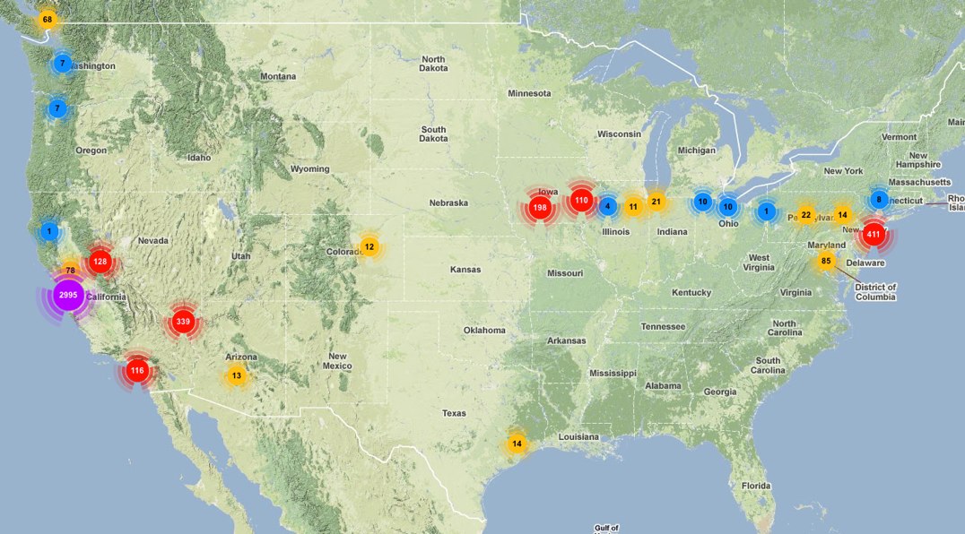
Upshot is I get credit for short trips to Houston, Phoenix, and Poughkeepsie, on top of all the other cities from last week's map. I'm gonna make 2011 even cooler.